Carte de l'Ocean Oriental ou Mer des Indes
Jacques Nicolas BELLIN
(1703 - 1772)
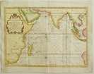
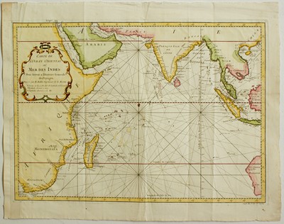
“Carte de l'Ocean Oriental ou Mer des Indes
Dressée pour Servir a l'Histoire Generale des Voyages
Par M Bellin
Magnificent engraved map of the Eastern Ocean or Indian Sea datable to 1746 and coming from the famous work of Prévost d'Exiles “Histoire Générale des Voyages” published in Paris by Didot from 1746 to 1789.
The map shows, starting from the left side, the east coast of Africa with Madagascar Island, South Arabia, the peninsula of India, Southeast Asia and the west coast of Australia still named Nouvelle Hollande where is noted the name of Shark Bay discovered by William Dampier in 1699.
Very nice example printed on laid paper with a watermark “Grape and letters PB” and countermark “Manufacture Royale”, with wide margins, untouched on three sides, very close to the platemark and partially replaced with old paper on the left one where there is a small loss of engraved area, with the usual vertical and orizzontal binding folds otherwise in excellent condition with a recent bright accurate watercolouring.
Bellin was the first chief “Ingénieur hydrographe de la Marine” and worked at the “Dépot de cartes, plans et journaux du Ministère de la Marine” for a long time, carrying out cartographic work of the highest quality, he was also a Member of the Royal Society of London.
References:
Goss “The Mapmaker's Art” London 1993 pag.298 e 299.
Moreland-Bannister “Antique Maps A Collector’s Guide” Oxford 1989 pag.136.
Size in mm: 350 x 485
Price: € 300,00